Back Àrea del Gran Dublín Catalan Área del Gran Dublín Spanish Dublin Handiaren Eremua EU Grand Dublin French ダブリン都市圏 Japanese Greater Dublin Aurie SCO گریٹر ڈبلن علاقہ UR 大都柏林地區 Chinese
Greater Dublin Area | |
|---|---|
Metropolitan area | |
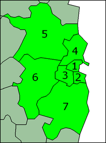
 Map of Dublin and its hinterland, showing: Dublin city (red), city and suburbs (orange), Dublin Metropolitan Area (Yellow), Greater Dublin Area (NTA) (Green) | |
 Maximal definition: 1. Dublin city, 2. Dún Laoghaire–Rathdown, 3. South Dublin, 4. Fingal, 5. Meath, 6. Kildare 7. Wicklow | |
| Country | Ireland |
| Area | |
| • Total | 6,986 km2 (2,697 sq mi) |
| Population (2022) | |
| • Total | 2,125,500 |
| • Density | 300/km2 (790/sq mi) |
| GDP | |
| • Metro | €230.366 billion (2021) |
| Time zone | UTC |
| • Summer (DST) | UTC+1:00 |
| Eircode (post code zones) | D01-D17, D02-D24, A41, A45, A63, A67, A82, A83, A84, A85, A86, A91, A92, A98, C15, K32, K45, K56, K67, K78, R56, W91, Y14, Y21 |
| Area codes | 01, 041, 042, 045, 046, 0402, 0404 |
The Greater Dublin Area (GDA; Irish: Mórcheantar Bhaile Átha Cliath), or simply Greater Dublin, is an informal term that is taken to include the city of Dublin and its hinterland, with varying definitions as to its extent. At the expansive end, it has been defined as including all of the traditional County Dublin and three neighbouring counties, while more commonly it is taken as the contiguous metropolitan area of Dublin plus suburban and commuter towns. The area is defined for strategic planning, and, for example, transport, and it is not a formal administrative or political unit.